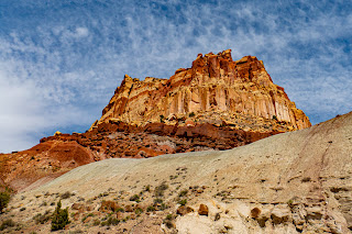
Our final park is just outside Torrey, Utah. We accidently discovered Capitol Reef National Park a few years ago, when we drove through part of it on our way to Bryce Canyon the first time from Durango, Colorado. The geologic formations on the western end of SR 24 (entering Capitol Reef from Glen Canyon Recreation Area) are the result of what's called the Waterpocket Fold. It was caused when the two tectonic plates underneath pushed only one part of the ground up and the other side down. It caused all of the layers to come to the surface and be subjected to erosion sooner instead of waiting for erosion and landslides to cause them to be visible. The erosion is a little different, too, because the underground water had already carved places that are now more readily available for use by rainwater. There is also a lot of betonite clay in this area, which prevents plant growth. But, betonite is known to hold a lot of liquid and minerals. Plain bentonite clay is gray, but it will change color depending on the mineral or other items it's holding. Uranium was found to be in some of the betonite in Capital Reef. The park is lovely. We went in the mid morning, and the light was harsh. I tried my best to get good pictures, but some are lacking, especially where the sky is involved. At some point, I might experiment with sky replacement, but not for the blog.
Chronicling our trip driving from Tacoma, Washington to Puerto Lopez, Ecuador and beyond
Saturday, June 1, 2024
A Reef in the Desert
Lots of the western side of the park has these holes in them. That's from the Waterpocket Fold and the way water erosion runs through them.
This is an old cabin that has been preserved.
Heading toward the Bentonite Hills and the Cathedral Valley, we find ourselves on yet another dirt road!
We had to turn back when we didn't think we had high enough clearance to ford the Fremont River. Really hated missing these.
We liked this little black boulder balanced at the top of the cliff. These black boulders are common in the area. They are basalt and andesite rock brought down from Boulder Mountain by the Freemont River and its tributaries while the canyons were forming.
The petroglyphs here weren't nearly as well preserved as in Parowan.
The difference between petroglyphs and graffiti is time.
This is a preserved school.
The lower, gray hills at the bottom of the cliffs is bentonite. These particular hills held uranium. The mines were closed down when the National Park Service took over the area.
Entrances and exits to the uranium mines have been gated up to prevent people from entering.
I decided to hike part of the Grand Wash, so we found ourselves on another dirt road.
I may not have been able to do The Narrows in Zion, but The Narrows in Capital Reef was much easier. I took the Grand Wash trail about half way until the canyon walls got narrower. Then I turned around and went back to Bruce and the car.
I met some wildlife along the way. The poster said there may be some big-horned sheep, but the way people decided to yell in the narrows (because they obviously have never heard an echo) apparently scared the sheep away. This guy wasn't scared, though!
I thought I saw a bird perched in one of the holes in the canyon wall, so I slowly moved closer.
It was a rock in a hole.
This yellow-bellied marmot was poised on a rock. I didn't have The Baby (the long lens) with me because we hadn't seen anything to use it on through the whole trip, so this was the best I could get.
After Capitol Reef, we spent a day just resting in Torrey before heading to Washington. There was a fenced herd of bison somewhere between Torrey and Salt Lake City.
We were welcomed to the Seattle area with rain and clouds. Tahoma (a/k/a Mt. Rainier) was having a day of rest. Hopefully, she'll come out soon.
Now to rest up for my next adventure.
Subscribe to:
Post Comments (Atom)


No comments:
Post a Comment